- Date and time: Saturday 15th August 2026, 9:00am
- Event type: Club run
- Start point: Club campsite at Bamford recreation ground,
- Grid ref: SK205828
- What3Words: ///chaotic.group.wander
- Distance: 20 kilometres
- Climb: 500 metres
Not to be confused with Rogaine (drug).
Rogaining is an orienteering sport of long distance cross-country navigation, involving route planning and navigation between checkpoints using a variety of map types. In a rogaine, teams of two to five people choose which checkpoints to visit within a time limit with the intent of maximising their score. Teamwork, endurance, competition and an appreciation for the natural environment are features of the sport. Championship rogaines are 24 hours long, but rogaines can be as short as two hours. – Wikipedia
A very flexible run, or race should you want to be competitive.
Groups / teams / pairs encouraged.
Starting at 9am from the Dark Peak Bamford campsite runners have a maximum of 4 hours (until 1pm) to visit as many Dark Peak points of interest as possible / reasonable, and return back to the campsite.
There are 50 points of interest in total spread across the Dark Peak, including Bob’s Rock, The Bus Stop, and The Source of the Derwent. Unfortunately these are mostly clustered a fair distance from Bamford.
So the twist is that you can use public transport or cycle. No taxis or driving yourself. Run back, get the train back, switch areas part way though the run? It’s up to you. Just be back at Bamford Rec. by 1pm.
Trains
First train to Edale from Bamford is 09:35 arriving in Edale at 09:46
First train to Grindleford from Bamford is 09:42 arriving in Grindleford at 09:50
Last train to Bamford from Edale is 12:34 arriving in Bamford at 12:43
Last train to Bamford from Grindleford is 12:28 arriving in Bamford at 12:35
Cycling
An off-road bike is recommended as this makes some checkpoint fairly accessible by bike. Little Switzerland, Boot’s Folly and a few others are close to roads and bridleways so can be picked up fairly easily by bike. You can also access the top of the Derwent Valley and the more northerly checkpoints should you wish to venture that far.
You must strictly stick to roads, byways, and bridleways (No cycling on footpaths or open moorland!).
Points of interest (Checkpoints)
Numbers, names, grid references, and points listed below.
I will try an update the following page with images so the uninitiated know what they are looking for: https://dpfr.org.uk/wp_dpfr/poi
Maps
Here are two links to detailed full size maps, downloadable from Google Drive:
Dark Peak Rogaine Map 1 (South)
Dark Peak Rogaine Map 2 (North)
These are both marked up 1:25,000 style OS maps which should print to A3 with reasonable enough detail to navigate.
Feel free to markup your own maps but contact Tom Saville not later than 12:00 Friday 14th if you require these A3 maps printing.
Scoring
Points scored for each checkpoint or indicated in the table below and on the maps. Note the 1894 Stone and the Sportsman have bonus points available (If you can’t get a pint at The Sportsman The Three Merry Lads will suffice).
For every minute you are late to finish (>4 hours) 3 points will be deducted from your score.
Enjoy the planning, and hopefully see you there!
Tom
|
Dark Peak 50th Anniversary Rogaine
4 hour score – Cycling, Trains and Busses allowed – Photographic evidence of checkpoint visits required |
|||
| No. | Name | Grid Ref. | Points |
| 1 | 1894 Stone | SK 13820 98552 | 40 (60)* |
| 2 | 1st Spring | SK 09152 90001 | 30 |
| 3 | 2nd Spring | SK 06713 88994 | 40 |
| 4 | 3rd Spring | SK 08300 86591 | 30 |
| 5 | 4th Spring | SK 10135 89170 | 30 |
| 6 | Alphabet Stone | SK 16036 89226 | 40 |
| 7 | Alport Scout Memorial (Lower) | SK 12428 92706 | 50 |
| 8 | Alport Scout Memorial (Upper) | SK 12223 92829 | 50 |
| 9 | Aztec Rock | SK 10799 88345 | 40 |
| 10 | B-29 Overexposed Wreck | SK 09063 94878 | 60 |
| 11 | Berristers Tor | SK 19903 92583 | 30 |
| 12 | Blackden Holly Tree | SK 12617 88952 | 30 |
| 13 | Bob’s Rock | SK 12319 88105 | 20 |
| 14 | Boot’s Folly | SK 23042 89909 | 40 |
| 15 | Brogging Moss Grotto | SK 20440 90856 | 20 |
| 16 | Cogman Cabin | SK 18556 92175 | 20 |
| 17 | Cold Side Knoll (Little Mam Tor) | SK 12903 84430 | 20 |
| 18 | Dog Stone | SK 07239 87717 | 60 |
| 19 | Fi-103 (V-1) Cruise Missile Crater | SK 18231 97068 | 30 |
| 20 | Foot Prints | SK 19086 93741 | 40 |
| 21 | Gilligan’s Cairn | SK 09266 84302 | 20 |
| 22 | Grinah Stones | SK 13043 96177 | 60 |
| 23 | Hartshorn boulder | SK 11208 87894 | 20 |
| 24 | Haunted House | SK 24748 86426 | 10 |
| 25 | Head Stone | SK 25575 87376 | 10 |
| 26 | Horsehill Tor cabin ruin | SK 08976 84906 | 20 |
| 27 | Hunter Wreck | SK 20864 94335 | 20 |
| 28 | Incline Wheelhouse | SK 24803 79197 | 30 |
| 29 | Ken’s Cairn | SK 27595 82163 | 40 |
| 30 | Kinder Ammo Box | SK 08678 87877 | 30 |
| 31 | Little Switzerland | SK 19298 78315 | 60 |
| 32 | Man-eating Bog | SK 18575 96084 | 10 |
| 33 | Mickleden Pond | SK 18709 98612 | 50 |
| 34 | Moz’s Knoll | SK 09559 86669 | 20 |
| 35 | New Cross | SK 21612 92869 | 20 |
| 36 | Nipple Stones | SK 17403 94485 | 30 |
| 37 | North Lees Pond | SK 23233 83764 | 20 |
| 38 | Ocean View | SK 25434 85952 | 10 |
| 39 | Ranger’s Grave | SK 26538 86477 | 10 |
| 40 | Ruby Stone | SK 26295 87018 | 40 |
| 41 | Skarratt’s Stone | SK 16716 99202 | 60 |
| 42 | Stanage Plantation Quarry | SK 25070 85297 | 20 |
| 43 | Stanage Sighting Observatory Ruin | SK 22590 86211 | 20 |
| 44 | Stone Igloo | SK 09120 83540 | 20 |
| 45 | The Bus Stop | SK 23065 85290 | 10 |
| 46 | The Source of the Derwent | SK 13231 96686 | 20 |
| 47 | The Sportsman | SK 28191 86143 | 10 (20)** |
| 48 | Wilfrey’s Needle | SK 18895 95312 | 20 |
| 49 | Wyming Brook Knoll | SK 27422 86403 | 30 |
| 50 | Yates’ Cairn | SK 27210 82419 | 40 |
|
* The 1894 Stone is worth 60 points if summited (photographic evidence is required)
** The Sportsman scores 20 points if you have a pint (photographic evidence is required) |
|||
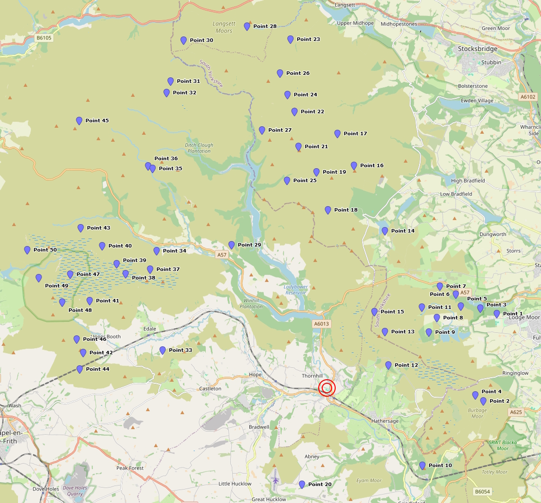
This map below shows approximate checkpoint locations. (Note that the numbering does not match the list above)