When training for events such as the Bob Graham or other long events it is customary to undertake long days out on the hills. There are a number of local challenges that have traditionally been used which save on the travel and get you to parts of the Peak that you might not otherwise visit. Knowledge of many of these challenges has been passed on verbally with only sporadic recording. The following is a list of some popular local challenges, with some details.
Elsewhere on the website, there is also information on Other Rounds. The dividing line between this page and that is (almost) entirely arbitrary. The division might be something to do with being localish.
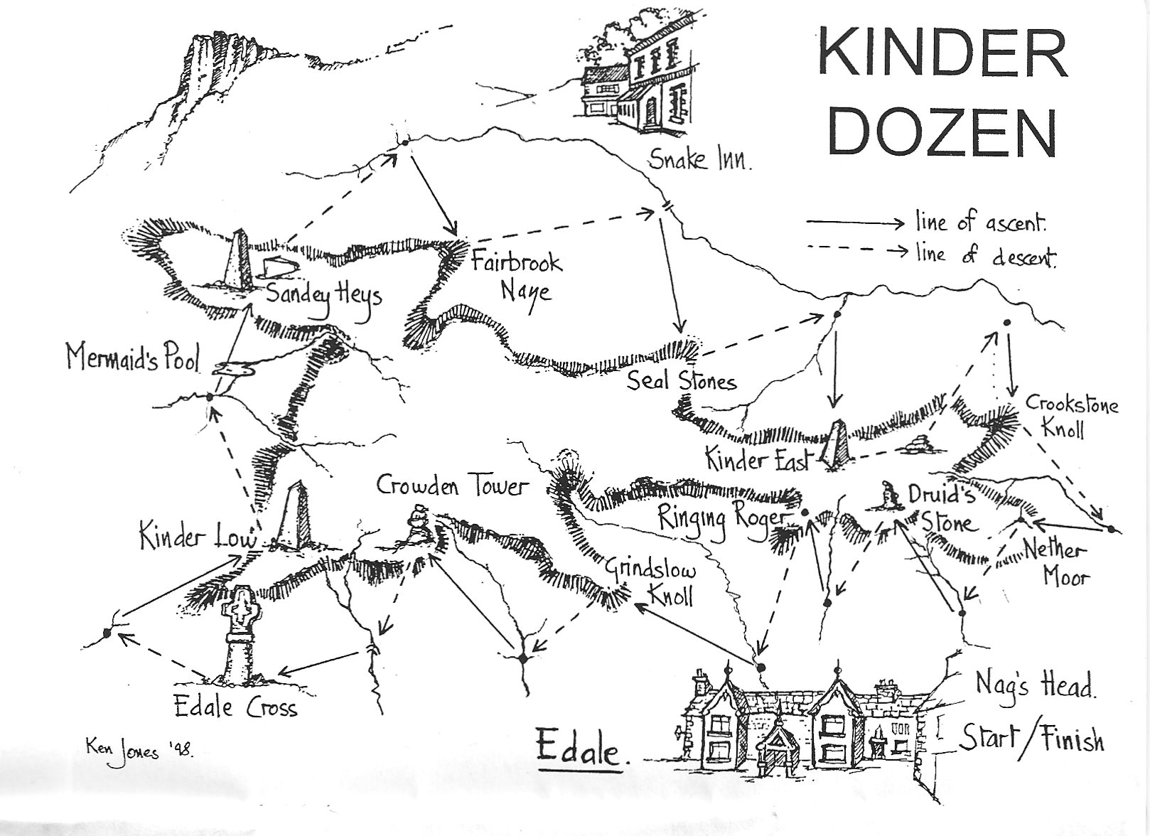
Kinder Dozen
The Kinder Dozen was initiated by Ken Jones in 1997/8 who produced a splendid A5 booklet describing the run and even some certificates. It involves 12 climbs and descents of the Kinder Plateau involving 10,000ft of ascent and totals 24 miles (the measure was made long before GPS so please do not correct). The set time limit is 12 hours but 8 hours is a more realistic challenge and more in line with a BG pace. The traditional start was from Edale village but as it is a long drive and has difficult/expensive parking, a start from Rowlee Bridge or Snake Inn is often used (note if starting here you do not traditional have to go to the Old Nags Head. Staying within access land at the bottom of Golden Clough is OK).
Known fast times:
Tom Saville 04:42:20 (31/03/2019)
Megan Wilson (F) 6:01 (01/02/2020)
Sue Richmond (FV) 6:30 (21/03/2020)
Eleanor Johnstone (F) 5:45 (30/03/21)
Former record times:
Lova Chechik 05:07:50 (02/03/2019)
Sally Fawcett (F) 6:23:00 (6th May 2017) – for Willy’s Birthday
Ralph Skrimshire 5:12:36 (May 2017)
John Boyle 5:20:32 (2012 or 2013?)
Geoff Briggs (Pennine) 5:45 12/05/2007
Kinder Killer
Another Ken Jones route. a variation of the Dozen, that follows paths and trods to circumnavigate the plateau. As a route following paths, it feels like some of the controls are a a bit arbitrary, depending on what you perceive to be the path. But none the less…
There are limited known times for the Killer.
Oli Johnson (MSen & M40) 5:18:42 (17th April, 2021)
Majka Kunicka (WSen) 6.32
Will Boothman (M40) 6.34 (26/02/2021)
Penny Collier (F45) & Sarah Broadhurst (F45) 7:56 (20th March 2015)
Mike Nolan (M45 & M50) 6:59:58 (2nd April, 2021)
Nicky Spinks (W50) 10:10:00 (5th April, 2021)
Geoff Briggs(Pennine) (M55) 8:00 (11/06/2014)
Jim Paxman (M60) 8:21 (13/05/2020)
Ken Jones (M70) 109:35:07 (14th to 20th April, 2021)
Heart of Darkness (AKA Myer’s Ladder to the stars)
This is a Mike Browell production.
Here’s Description of the routeThere are few known times for this, but Willy describes his outing as reasonably leisurely. Willy Kitchen & Rich Bradbury 6:51 (March 2014)
Basil Moss 6:26 August 2021
Hello, I’ve had my eye on the Heart of Darkness route since joining the club, and actually went out to run it last Friday. I’m not sure who looks after the section of the website with the long distance challenges on, but wonder if they’d like to know my time as it’s slightly faster than the 6:51 by Willy Kitchen and Rich Bradbury – I got back to the car park in 6:26. The route was absolutely awesome/abominable and I was whimpering with every footfall on the last few descents. The bracken added significantly to the challenge – at one point descending to Westend on the return leg my ankle got tangled and I found myself hanging upside down like I’d been caught in a trap – was quite difficult to free myself! The bog seems to have permanently stained my ankles and I can’t wash it off, so I feel like the Dark Peak has left it’s mark on me. Do let me know if there are any faster times, I’d actually forgotten what the recorded time for it was when I set off and for some reason got it into my head that I’d be back in four or five hours, so was quite despondent when I got back thinking I’d been terribly slow! Thanks, Basil
Dark Peak Stones
Another of Ken Jones’s. The long version is to visit all the Stones in the Peak district from the top of the A57 back to the Sportsman. The short version only back to the Ladybower.
15 Trigs Link
A classic old route visiting the 15 trig points originally included on the Harvey Mountain Map – Peak District – Northern half, as used in the Karrimor International Mountain Marathon 1984. To be completed in 15 hours, starting at the Sportsman, but has also been started ‘on the other side of the Pennines’. The trigs are Rod Moor, Emlin, Back Tor, Margery Hill, Outer Edge, Alport, Shelf Moor, Cock Hill, Harry Hut, Sandy Heys, Kinder Low, Brown Knoll, Blackden, Win Hill, High Neb. Was a very competitive event at one time and certificates given for early completions.
Current Men’s record: Tom Saville 8:52:25 (13/04/2019).
Stuart Walker set a record of 9hrs 57 mins in November 2013, prior to that Andy Harmer held the record for fastest Dark Peak completion of 10hr 04min, set in 1987, though Simon Bourne snuck in just under 10 hours in 2011.
11 Trigs
A variation of the 15 this time all the White Peak trigs shown on the Harvey Mountain Map – Peak District – Southern Half but not included above. Big Moor, High Rake, Wardlow Hay Cop, Edgerake Mine Wheston, Bole Hill, Townend Farm Buxton, Cop Mine, Man Tor, Durham Edge, Sir William Hill, Stannage Edge South. This time in 11 hours. Needs more planning as water and access can be troublesome.
25 Trigs
This has been done but only maybe once (not true any more) by Pete Simpson in 1991 in a time of 23:48. A challenge there if there ever was one?
We now have a time set by Stuart Walker of 23:42 on 26/27 May 2016. Apparently Pete Simpson accidentally (!) added Flask Edge trig; Stuart avoided Flask Edge but added the Ox Stones, so still did 26 trigs.
30 Trigs
Peak District 27 trigs extended to 30
Oli Johnson 22:14 4/9/2020
The Bradfield Boundary
This is a long standing run that has taken place every year since its initiation in 1994 to celebrate the 100 years anniversary of Bradfield Parish Council. Medals were even given by the Parish Council on the first year. It was run initially on the last day of the year but now moved to its usual position on the third day of Christmas unless this falls on a Sunday when access problems cause a days delay. Starting at Loxley School at 6.00am and the schedule is to complete the round in 12 hours. Not run as a race but look at the Dark Peak Calender around Christmas time. Traditionally billed as 48 miles but that was before someone ran round with a GPS.
Dark Peak (Four) County Tops Link
Traditional start in Hayfield but maybe not. High Stones/Margery Hill, Black Hill, Black Chew Head and Kinder Scout each in a separate county 40 miles plus all in 24hrs.
Bar Dyke (Bradfield) 04.00
High Stones 05.24
Woodhead Road 07.21
Black Hill 09.36
Black Chew Head 10.45
Bleaklow Head 14.20
Kinder Top 17.38
Shining Tor 03.30 [ 2hrs too long due to inexcusable mistakes]
Cheeks Hill 05.06
Bar Dyke (Bradfield) 19.58
39hr 58min taking in 95 miles travelled
If anyone should rise to this challenge a new schedule of your times (without the error) would be appreciated.
This can be extended to the Six CountyTops as done by Roger Baumeister 10/06/2013 in 39:56. Roger is of the oppinion that the pure route for the sSix County Tops is from the same start/finish point. In his case: from, and returning to Bar Dyke access point.
Loxley 5 Trigs
A local training run but one that has seen some competition over the years.
Tom Saville 2:29 10th July 2018 As Strava
Tim Rutter 2:38 15th April 2019 As Strava
Neil Northrop 2:41 20th June 2015 As Strava
Stuart Walker 2hr 57min 14th April 2013.
Tom Westgate held the record of 2hr 59min since before records began (1996/7 ish)
The Dambuster

A days outing round Derwent Valley for connoisseurs created by Tom Westgate. Starting at The Derwent Dam wall visiting Pike Low, John Field Howden, Back Tor, Low Tor, Berristers Tor, Gravy Clough Cabin, Wet Stone, Howden Dam, Cold Side Crags, Bull Stones, Rocking Stones, Horse Stone, Barrow Stones, Grinah Stones, Black Clough, Alport Trig, Fagney Clough, Green Clough, 483 point at Rowlee, Gores Heights (top of land slipped crags) and back. Maybe only completed by four or five people so far?
19/01/14 update, now with the inclusion of Willy Kitchen and Ruth Batty there may now be as many as seven or even eight people to have done the round.
Kinder Trigs
Josh Williams’ Kinder Trigs is more runnable and shorter than the Kinder Dozen and Killer – something like an AL fell race. It’s also hopefully less affected by bracken and swollen rivers so can be completed in most seasons and weathers.
The route can be started at any of the 6 checkpoints and in either direction. There is no fixed route as long as the checkpoints are visited in order from your chosen start point (to create a circular route), and you finish where you started. Your route should respect private land and adhere to rights-of-way and access land. Whichever way you choose to go there will be 3 decent climbs and descents.
The checkpoints are:
– Fairbrook Footbridge – SK 114 901
– Blackden Trig – SK 129 878
– Upper Booth Bunkhouse – SK 102 853
– Kinder Low Trig – SK 079 870
– Kinder Reservoir (path junction below dam wall) – SK 052 880
– Sandy Heys Trig – SK 077 893
Approx. distance: 23km
Approx. elevation gain: +1400m
Josh will keep a record of completions and records for age categories. Please send times,
start/finish checkpoint, clockwise/ anti-clockwise, club and any witty anecdotes to joshw661 [at] gmail dot com
This route was devised during lock down restrictions to make up for Josh missing all those Long A races.
Current records:
MV50 Jon Morgan & Neil McAdie 3:39:14 (05/02/21)
MV40 Tom Brunt 2:23:35 (06/03/21)
MSen Josh Williams 2:23:24 (06/03/21)

Bradfield Six – cycling

OK a bike ride not a run unless you are a keen hilly road runner. Most of the roads have just been re-surfaced so better times should be possible.
Women
Hannah Saville 1:43:41 25/4/2020 Strava
Karen Ledger 1:48 15/06/2013
Men
Steve Yeoman 1:35:16 12/05/2019
Tom Saville 1:35:28 12/14/2020 Strava
James Banyard 1:44 30/08/2013 (unconfirmed)
Richard Hakes 1:55 28/08/17 (over 60’s record)
Tim Ray 1:51 17/06/2021
Tim Ray 1:58 28/08/17 https://www.strava.com/activities/5487206099
Steve Martin 1:58
Tom Westgate 2:06 24/08/2017
Tim Hawley and cousin Nick 2:09 27/08/2017
Paul Sanderson 2:11 20/08/2017
Mike Browell (but turned left out of High Bradfield) 2:44 11/08/2014
The Off Road Bradfield Six – probably on a bike
I am not totally aware of the providence of this but Tim Rutter, Dominic Watts and Dave Holmes have had something to do with it.

2020-05-07–Off-Road-Bradfield-Six-Clock.gpx
2020-05-07–Off-Road-Bradfield-Six-Anti-Clock.gpx
Some more esoteric options…
The Kozen
A Killer and Dozen, back to back.
Ben Kelsey 16:05:51 (Feb 2021) – open record.
Ben logged it as 53 miles & 18,000 feet
Initially done by Willy Kitchen & Dave McGuinness – clockwise Dozen followed by anti-clockwise Killer – on 24th May 2014 in 18 hrs 17 mins (M40 record) … “were it not for a rather unfortunate navigational on the last climb (in my [Willy’s] defence, in the dark), then we’d most likely have beaten 18 hour schedule we were running to.”
Double Dozen
Just that, one Kinder Dozen. Followed by another one!
Jim Paxman 18:18:34 (May 2018)
Walker-Lowe Round (25 trigs)
Inaugural Round Stuart Walker 23:54 2019
2nd completion Tom Pape 22:37 (new record) 10/7/20
It might be thought of as wise not to undertake this as a training run ahead of your BG. When did that ever stop anyone in this club?
James comments on the progenesis of this route:
Dark Peak 24 Trigs. Every time I see Stuart Walker I tell him I’ve come up with this mystical new route he should run.This is my attempt at plotting a true Dark Peak 24 Trigs (in 24 hours) all on the DP OS Map. None of this dodgy white peak trespass nonsense.
It starts at the Sportsman and as per the normal 4 (anitclockwise) then heads north to cover Scout Nab, Dead Edge End, Snailsden Pike End, Black Hill, Featherbed Moss, Alphin and Wild Bank hill. It ticks off the rest of the 15 in a slightly altered order and adding in Mam Tor before finishing via the Cowper and Ox stones.
It seems to give what could be an interesting route with lots of potential route choice, navigation and rough ground. I’ve ommited Hey edge (and potentially others?) as it’s not marked on the map as a proper trig.
A very (VERY) rough attempt at mapping it gives me ~130km and 4000m, I suspect it’s more like 150km and a more height but hard to say.
Is it achievable? Is it totally ridiculous? Too convoluted?
Interested to hear people’s thoughts and potentially see someone (most definitely not me) have a go.
Hopefully my attempt to map it is attached and viewable
James Lowe
